Presidential Range New Hampshire: The Ultimate Hiker's Guide
Presidential Range New Hampshire: A Hiker's Ultimate Guide
Stretching across the skyline of New Hampshire's White Mountains, the Presidential Range is a place of complete beauty and formidable challenges. The Presidentials are home to the highest peaks in the northeastern United States, including the beautiful and famous Mount Washington, this range is a bucket-list destination for serious hikers, travelers, and nature lovers. Its stunning, above treeline views are matched only by its notoriously severe and unpredictable weather, earning it a reputation as both a breathtaking paradise and a proving ground for mountaineers.
Whether you're dreaming of completing the legendary Presidential Traverse or looking to explore its beautiful summits, proper planning is not just recommended...t's essential. This guide provides an in-depth look at everything you need to know, from the individual peaks, popular itineraries, down to the specific training and gear required to tackle this rugged landscape safely and successfully. So without further or due lets dive in!
What is the Presidential Range and Why is it Famous?
The Presidential Range is a chain of mountains forming the backbone of the White Mountains in New Hampshire. Its most prominent peaks are named after U.S. presidents and other notable public figures. The range is broadly divided into the Northern Presidentials (Madison, Adams, Jefferson) and Southern Presidentials (Washington, Monroe, Eisenhower, Pierce), connected by a high altitude ridge that offers some of the most spectacular and exposed hiking on the East Coast.
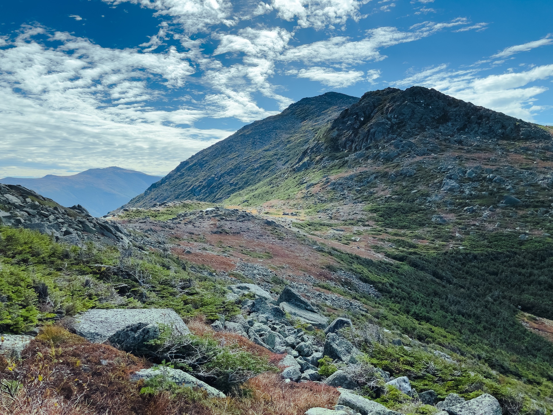
The fame of the Presidential Range comes from two primary sources: its beauty and its danger. The upper elevations are a rare, fragile alpine tundra environment, characterized by low growing sedges, lichen-covered rocks, and 360-degree views that can stretch for a hundred miles on a clear day. However, this exposure is also its greatest hazard. The range, particularly Mount Washington, is a convergence point for major storm tracks, leading to what is often called the "world's worst weather." Wind speeds have been recorded at 231 mph (the second highest wind speed ever recorded in history), and it's not uncommon for snow and freezing temperatures to occur even in the middle of summer.
The Peaks of the Presidential Range: A Summit-by-Summit Overview
The core of the Presidential Range includes several 4,000+ footers, each with its own distinct character. Most traverses follow the Appalachian Trail from north to south, tackling the peaks in the following order:
1. Mount Madison (5,367 ft)
The journey begins with a challenge. Mount Madison, the northernmost sentinel of the range, is a steep, rugged cone of jumbled boulders. The climb is a intense introduction to the alpine environment, but the reward is immediate: your first sweeping view of the entire ridge you're about to traverse. Nestled in the saddle between between Madison and Adams is the AMC's Madison Spring Hut, a welcome sight for weary legs.
2. Mount Adams (5,774 ft)
Often considered one of the most demanding peaks in the Whites, Mount Adams is not a single summit but a massive, sprawling massif of rock. As the second-highest peak in the range, its summit plateau is a vast, confusing field of rough stones and boulders that requires careful navigation, especially in poor weather. The effort is repaid with a profound sense of wildness and spectacular views from its true summit.
3. Mount Jefferson (5,712 ft)

Continuing south, the trail leads to Mount Jefferson. Its summit is marked by a jagged, castellated ridge that provides a thrilling scramble. The peak offers a unique perspective, looking back at the imposing bulk of Adams and ahead to the looming cone of Washington. The relative flatness of the "Monticello Lawn" on its northern approach provides a brief, welcome respite from the relentless rocks.
4. Mount Washington (6,288 ft)

The crown jewel and the highest point in the northeastern United States. Mount Washington is a world unto itself, famous for its extreme and unpredictable weather. The climb to its summit is the physical and psychological crux of the traverse. Unlike the other peaks, the summit is home to the Mount Washington Observatory, a state park visitor center, the Cog Railway, and the Auto Road. Standing amidst the summit structures after hiking through miles of raw wilderness is a wonderfully surreal experience. Here, you'll encounter a mix of fellow hikers and tourists, making it a refreshing return to civilization after the solitude of the other peaks.
5. Mount Monroe (5,384 ft)
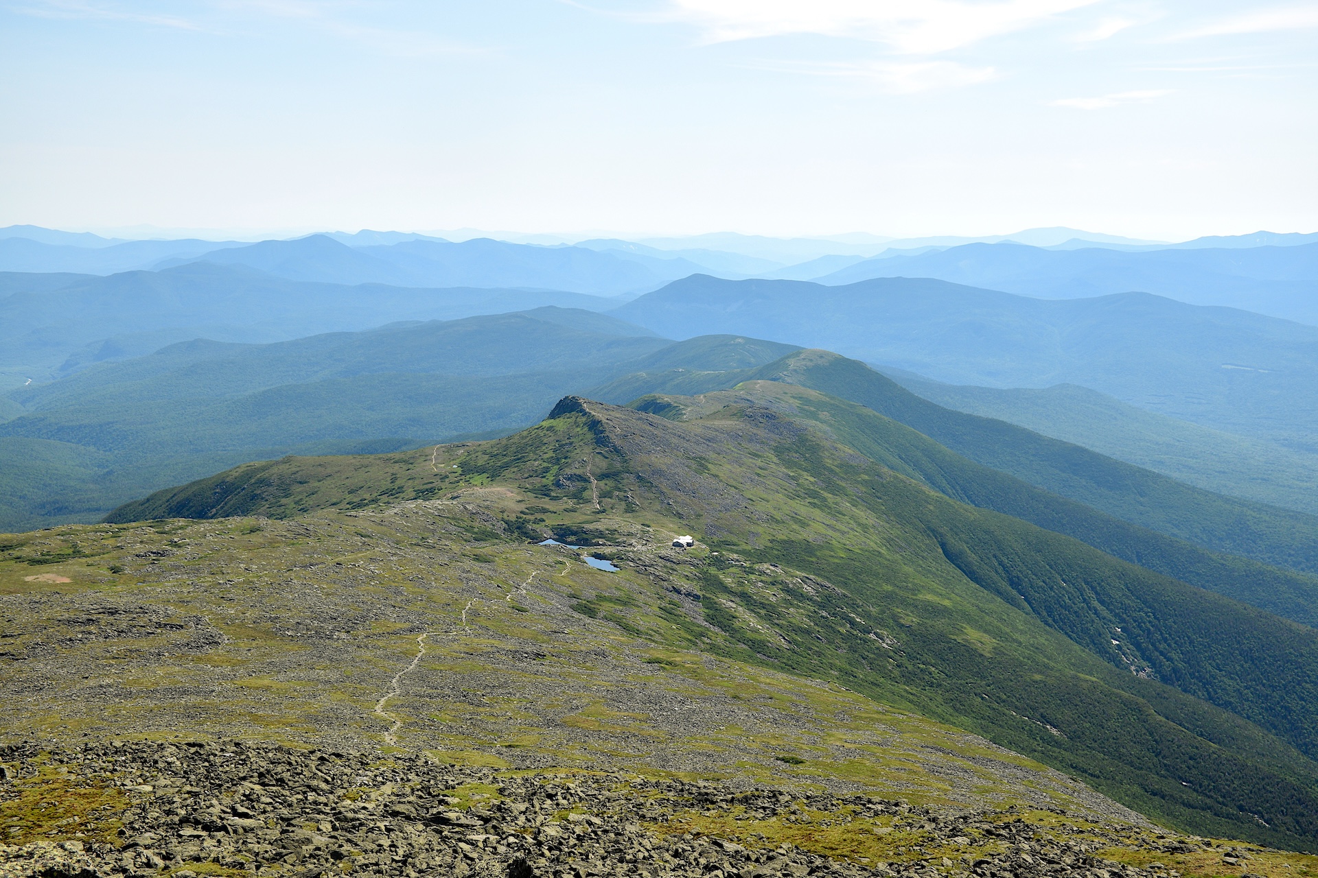
Just south of Washington, past the iconic Lakes of the Clouds Hut, sits Mount Monroe. A much more straightforward and pleasant climb, its twin summits are a spectacular viewpoint. Many hikers argue that Monroe offers the single best view of Mount Washington, showcasing its dramatic western flank and the deep chasm of Oakes Gulf.
6. Mount Eisenhower (4,780 ft)
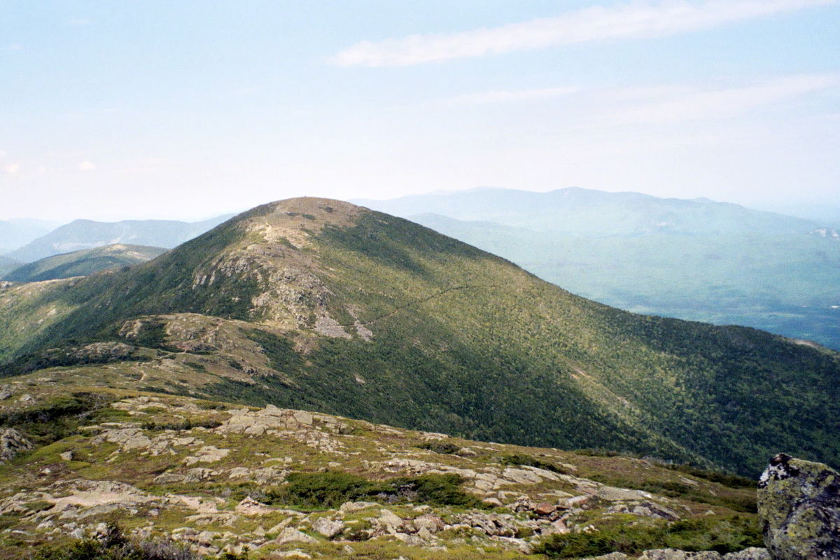
Named for President Dwight D. Eisenhower, this peak is easily distinguished by its massive, perfectly bald, and nearly flat summit. A short loop trail breaks from the AT to circle the summit cairn. The unobstructed 360-degree panorama from this "alpine runway" is unbelieveable, offering views south towards the lower peaks of the range and the vast Pemigewasset Wilderness beyond.
7. Mount Pierce (4,310 ft)

Formerly known as Mount Clinton, Mount Pierce serves as the southern anchor for most classic Presidential Traverses. While much of its trail is below treeline, its summit is a beautiful, open rock clearing. It provides a final, magnificent look back across the southern Presidentials, a perfect spot to reflect on the incredible journey before descending into Crawford Notch.
Planning Your Adventure: The Presidential Traverse and Other Itineraries
The most famous challenge in the range is the Presidential Traverse, a grueling 20-23 mile trek that crosses all major summits. Elite trail runners might complete it in under 12 hours, but for most strong hikers, it's a very long single-day effort or a more approachable two-to-three-day backpacking trip. Logistics are key the two main trailheads, Appalachia in the north and the Crawford Path in the south, are miles apart. Hikers typically arrange a car spot with a friend or use a shuttle service to connect the two points .
For those not ready for the full traverse, the range offers countless other incredible itineraries. A popular two-day option involves hiking from Appalachia to the Madison Spring Hut or Lakes of the Clouds Hut, spending the night, and finishing the traverse on day two. This breaks up the mileage and elevation gain while allowing you to experience a spectacular sunset and sunrise from above the treeline.
Day hikers have excellent options as well. A classic loop ascends Mount Eisenhower and Mount Pierce from the Crawford Path trailhead for incredible rewards with less commitment. Another favorite is the loop over Mount Adams and Mount Madison, which provides a taste of the rugged northern peaks. For a shorter but still challenging day, an ascent of Mount Washington via the Tuckerman Ravine Trail is an iconic White Mountain experience.
Conquering the Challenge: How to Train for the Presidential Range
Underestimating the physical demands of the Presidential Range is a common and dangerous mistake. The terrain is relentlessly steep and rocky, with the full traverse involving nearly 9,000 feet of elevation gain. A dedicated training plan is crucial for a safe and enjoyable trip. Your preparation should focus on three key areas: cardiovascular endurance, muscular strength, and hiking-specific conditioning.
For endurance, incorporate activities like running, cycling, or swimming for 60-90 minutes, 3-4 times a week. To build strength, focus on your legs and core. Squats, lunges, and step-ups are excellent for building the power needed for steep ascents, while planks and other core exercises will improve stability on uneven terrain. Most importantly, nothing prepares you for hiking like hiking. Go on progressively longer and steeper hikes with the weighted pack you plan to carry. This not only builds physical readiness but also allows you to test your gear and nutrition strategy.
Essential Gear and Seasonal Considerations
The saying in the Whites is, "Hope for the best, but pack for the worst." The weather can change in minutes, and proper gear is your primary line of defense. Even on a perfect summer day, you must carry the "10 Essentials," including extra layers, a rain jacket and pants, a headlamp, navigation tools (map, compass, and GPS/satellite messenger), and an emergency shelter . Cotton clothing is extremely dangerous when wet, so stick to wool or synthetic materials.
Seasonal conditions dramatically alter the difficulty and risk. Summer (July-August) offers the most stable weather, but thunderstorms are a serious threat above treeline. Spring (May-June) is a time of transition, with melting snow creating slick ice and dangerously swollen river crossings. Fall (September-October) brings beautiful foliage and fewer crowds, but also shorter days and a higher chance of early-season snow and ice. Winter in the Presidential Range is a different sport entirely, requiring technical mountaineering skills, avalanche training, and specialized gear like crampons and ice axes. It should only be attempted by experienced and properly equipped winter mountaineers .
The AMC Huts: Your Home in the High Peaks
One of the most unique features of the Presidential Range is the Appalachian Mountain Club (AMC) high-hut system. These eight lodges are strategically placed along the Appalachian Trail, providing hikers with shelter, hot meals, and drinking water in the heart of the mountains. Staying at a hut like Madison Spring, Lakes of the Clouds, or Mizpah Spring allows you to travel with a lighter pack, as you don't need to carry a tent, sleeping bag, or cooking equipment.
Each hut is staffed by a "croo" that maintains the facility, cooks breakfast and dinner, and provides weather updates and trail advice. Reservations are required and often book up months in advance, especially for summer weekends. While the huts offer significant comfort and safety, they are not for everyone. For those seeking more solitude or a traditional backpacking experience, designated backcountry campsites like The Perch or Nauman Tentsite provide a more primitive alternative, requiring a tent and full camping gear.
Safety and Stewardship in a Fragile Environment
Safety in the Presidential Range begins with humility and respect for the mountains. The single most important factor is the weather. Always check the higher summits forecast from the Mount Washington Observatory before you go, and be prepared to turn back if conditions deteriorate. Hypothermia is a risk year-round, and getting caught above treeline in a storm can be life-threatening. Know the signs and have a plan to descend to safety quickly.
Beyond personal safety, we have a responsibility to protect this unique environment. The alpine zone is incredibly fragile. A single footstep off-trail can destroy plants that take decades to grow back. Always stay on the marked path and walk on durable surfaces like rocks whenever possible. Practice Leave No Trace principles rigorously: pack out everything you pack in, including food scraps. By being prepared and mindful, you can ensure the Presidential Range remains a wild and beautiful sanctuary for generations to come.
Conclusion
The Presidential Range of New Hampshire is more than just a line of mountains; it's a journey that tests your limits and rewards you with an unparalleled sense of accomplishment. From the rocky cone of Adams to the sweeping lawn of Eisenhower, each summit offers a new perspective. By planning meticulously, training diligently, and respecting the power of the mountains, you can safely unlock the adventure of a lifetime in one of America's most iconic alpine landscapes.
Subscribe to our newsletter
Lorem ipsum dolor sit amet, consectetur adipiscing elit. Suspendisse varius enim in eros elementum tristique.
Related posts
Check out our other blog posts!